
Leveraging technology to help farmers maximize their potential
India is a signatory to the UN Sustainable Development Goals. Farming techniques that are sustainable and environment friendly, and also provide sustainable livelihood options to the farmers will support in achieving the UN- Sustainable Development Goals by 2030.
Approximately 60 percent of the Indian population works in the industry, contributing about 18 percent to India's GDP. However, a huge population of this demographic live in rural areas with a monthly income of Rs. 2400, which again is conditional on the availability of groundwater resources to carry out agricultural operations and lack the technology to conduct systematic groundwater targeting, prospecting, and exploration. By virtue of this, they are left stranded at the mercy of pseudo-scientific water dowsing methods using twigs & coconuts which result in a 72% chance of failure to discover underground water resources. On average, a farmer has to spend an additional Rs.70,000 for drilling operations when no water is found. This unorganized system has led to many farmers committing suicide in various parts of India.
In this context, role of organizations that work with a scientific mindset comes to the rescue. Aumsat is a remote groundwater monitoring technology, focused on helping farmers locate underground water resources along with optimizing their energy, water use efficiency and economic losses associated with farming operations with high precision and 75% reduced cost. Most of the solutions in the market are focused on groundwater detection. But research has given them the power to carry out predictive analytics and forecasting abilities unlike any other solution present in the Indian Market.
Aumsat has an exceptional value proposition backed by cutting-edge technology. Unlike conventional costly and time-consuming methods used in groundwater exploration such as acoustic, resistivity, and transient electromagnetic surveys Aumsat’s services can help detect groundwater zones at a high rate of precision without physically being present on the field thereby saving costs up to 75%.
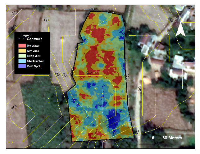
The Banda District (4413 km2) of Uttar Pradesh situated in the Bundelkhand Region is home to about 800,000 farmers. Nearly 48% of the cultivable area is dependent on groundwater irrigation. Targeting reliable and good quality sources of underground clean water is a big challenge in the region, without a technology-driven approach, conventional methods rely on inaccurate, time-consuming, costly, and pseudo-scientific water dowsing methods. The Nationalized banks end up accumulating NPA’s when a farmer ends up drilling a dry well in 72% of the cases. Unlike developed countries such as the USA, the UK, etc., the application of radar technology for groundwater targeting still remains a challenge in India. Using a combination of multi-frequency satellite radar, UAV-mounted radar, and ground penetrating radar, a pilot was implemented by Aumsat Technologies to detect groundwater resources in parts of the Banda, Naraini, Baberu, Palani, and Atarra Tehsils of the Banda district. Satellite-based Synthetic Aperture Radar (SAR) having penetration depth up to 30m in dry soil was used to detect groundwater presence in subsurface fissures and cavities. Radar interferometry technique was also used to detect cm level ground displacement due to the overexploitation of groundwater resources and finally UAV based passive microwave radiometer and ground penetrating radar were used for field validation and truthing. The traditional survey technique that would otherwise take 3-5 years for scanning 4413 sq km of the land took Aumsat 1 month period for targeting and locating underground water resources in the entire Banda District with high precision and 75% reduced cost. By the use of technology, they were able to benefit a farmer population of 800,000.
Having interacted with 1329 stakeholders’ from the groundwater industry, people from the organisation found out that in terms of speed and accuracy of surveying land for groundwater, there is a big gap for unlocking a scalable solution. Hence the banks who give loans to farmers need transparency and auditability, FPO and NGOs working in the areas of water conservation need accuracy and finally, the farmer needs affordability. Their primary competitors are watermen who carry out surveys using twigs and coconuts, drilling services that conduct hit and trial borewell operations, and geophysical surveyors who carry out expensive and time-consuming surveys. However, the reason they have found success is their work is backed by science and their technology is validated by the ICAR water technology division and Central Groundwater Board.

CSRBOX
CSRBOX.org is Asia's largest CSR platform with an in-depth CSR portfolio of over 1050 companies and 10000+ CSR projects. The platform works as a bridge between the development sector, and business community, government agencies and academic institutes to bring together opportunities on one platform and create a knowledge base for thematic interventions. A few of our clients are UNICEF India, IBM, BOSCH Ltd, HCL Foundation, Genpact, Diageo, Bajaj Foundation etc.We have projects, platforms and partnerships (3Ps) based approach for social impact in India
IMPACT TALKS

|

|

|

|

|

|


